Below are my sketches - and a little bit of history about the two important London buildings I sketched Admiralty Arch and Horse Guards. Both are Grade 1 Listed Buildings - meaning they are very important in terms of both architecture and heritage.
I've already written about the sketchcrawl for London Urban Sketchers and I'm not going to do it again. However you can READ more about the sketchcrawl:
- the results August 2015 Sketchcrawl - Notes, photos and sketches and
- the plan Let's Draw - Trafalgar Square, The Mall & St James Park - Sunday 16th August 2015
- plus view the map of the locations
Admiralty Arch
 |
| Admiralty Arch - drawn while sat in the middle of The Mall (16th August 2015)pen and ink and coloured pencils |
 |
| I focused on the drawing and added more colour when I got home- building up layers to get intensity of colour can sometimes take a bit of time |
It used to be used as government offices and Ministers used to have flats at the top but it's now been vacated and let for use as a hotel (which as yet has not yet happened).
The central gate of Admiralty Arch is typically only ever opened to allow the Monarch to pass through. If you sit the other side of it is a great place to get a full view of The Mall when the traffic is normal - unlike when we were there and most of The Mall was coned off for pedestrians only.
Horse Guards
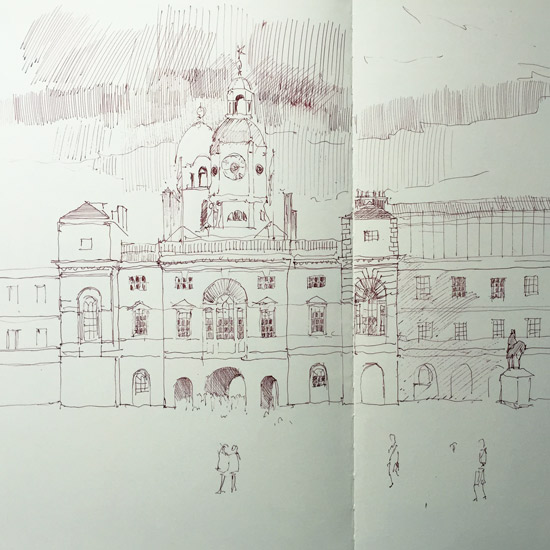
This is my sketch of Horse Guards and the Parade Ground - which is where they held the drumhead service for the VJ 70th Anniversary. It's also where they hold the trooping the colour every year on the Queen's Birthday. You can see a drawing of what it looked like in 1695 at the end of this post.
Did you know that Horse Guards houses the space used for the Tilt Yard used by the original Whitehall Palace? (see a map of this in 1680 at the end of this post)
I had great plans to include the London Eye but needed a different perspective or a wider sketchbook! I think I'm going to go back and have another go. It's a view I walk past regularly and I've always wanted to have a go.
 |
| A view of Horse Guards and the Parade ground (16th August 2015)pen and ink in a Moleskine sketchbook |
 |
| Plan of the Palace of Whitehall 1680 - right click and open in a new tab to see a much LARGER version The Tilt Yard is at the top. The map has the river at the bottom and the parkland at the top. |
 |
| View of the Palace of Whitehall by Leonard Knijff, c. 1695-7 - right click and open in a new tab to see a much LARGER version Thames is at the bottom of the picture and the space now occupied by St James Park is at the top You can just see the entrance to Horse Guards in the middle |

