Showing posts with label New England. Show all posts

Monday, November 26, 2007

Interior landscapes with food - a Sketchbook

Lots of my sketches on my travels end up being done in restaurants, cafes and tea rooms. One day I may do a book.........

In the meantime, this summary post:

  • lists all the sketches by title, with their locations. I've organised it geographically in case anybody else fancies having a go at sketching the same view.
  • links to the locations in the title of the place

I'm also planning to post more of my sketches in various restaurants and other eateries which have already appeared on my other blog - see 'Making A Mark' - Interiors. While most of the sketches are of interiors (hence the title), a few involve facilities where the eating and drinking frequently takes place on a terrace outside eg Kew Gardens. Some are purely are of my view while I was taking refreshments.

Also ...... a post about my tips for people wanting to sketch in restaurants and other eateries.

10 "Dos and Don'ts" for how to draw people while eating


An Orangery Afternoon Tea
Kew Gardens

London (from west to east)

Royal Botanic Gardens, Kew

Chelsea

Kensington Palace

Rex Whistler Restaurant 
Tate Britain, London

Tate Britain

Piccadilly - Royal Academy of Arts

St James Restaurant
Fortnum & Mason, London

Piccadilly - Fortnum and Masons

Mall Galleries

National Gallery

The National Cafe
National Gallery, London

National Portrait Gallery: Portrait Restaurant and Portrait Cafe

    Tate Modern

    "Fish! Restaurant, Borough Market
    Bankside, London

    Bankside


    City of London - Smithfield

    Northern England

    The Ferry Inn, Cookham
    Berkshire, England

    Southern England


    Europe

    Menu du Terroir, La Grillade Gourmande, Épernay
    Auberge du Terroir
    Servon, Normandy

    France

    Italy

    Trattoria alla Madonna
    Venice
    Venice:


    USA

    USA - California
    Tommys
    San Clemente, California

    USA - Arizona

    Cafe on Route 66
    Grants, New Mexico, USA

    USA- New Mexico

    USA Massachusetts

    Burdicks, Walpole,
    New Hampshire, USA

    USA - New Hampshire

    USA - Vermont

    USA - Maine

    In Good Company,
    Rockland, Maine


    More travel sketches 


    You can see more of my travels with a sketchbook on my website or by clicking the links to the summaries of blog posts for different areas in the right hand column. These are the links to my travels with a sketchbook in London; England; Venice and the USA.

    This post will be updated as new sketches are added to this blog.

    Monday, March 19, 2007

    Rotherhithe: the Mayflower and Brunel

    Rotherhithe: the Mayflower Inn, St Mary's Church Brunel's Engine House
    8" x 10", pencil and coloured pencil in Moleskine
    copyright Katherine Tyrrell

    The first of my sketches on the 13th Internationl Sketchcrawl is this view done from the Thames Path in Wapping. On the south side of the River Thames is Rotherhithe and a site associated with the start of a famous journey. The ship called the Mayflower which carried the Pilgrims to Plymouth, Massachusetts in 1620. was based in Rotherhithe. In the summer of 1620. she was hired to transport a group of colonists and set sail from close to the very small white building just to the left of centre - which is the Mayflower Inn. The ship's co-owner and captain, Christopher Jones, lived in Rotherhithe and was buried in the churchyward of St Mary's Church in 1622. You can see the church steeple to the right of my sketch. You can also see the chimneys associated with the Brunel Engine House and the Thames Tunnel which Brunel built under the Thames between Rotherhithe and Wapping.

    Rotherhithe
    Rotherhithe is nearly a peninsula on the south side of the Thames in the London Borough of Southwark. In the past it's always had a very close association with the sea. Seafaring, ship building, and ship breaking were major industries in the area for centuries and its maritime heritage still dominates the area.

    Many great voyages started or finished here, including Drakes’ circumnavigation of the globe between 1577 and 1580 in the Golden Hind (a replica of which is now at Bankside where I sketched for the July 2006 Sketchcrawl).

    The big commercial docks area in the Rotherhithe area fell out of use in the second half of the twentieth century and the area declined before being regenerated over the last twenty years. Many of the old Wharf side buildings such as the ones in the sketch have been converted to residential use and now contain expensive apartments.

    The Mayflower
    Between 1609 and 1622, the Mayflower was based at Rotherhithe and used primarily as a cargo ship, involved in active trade of goods (often wine) between England and other European countries and was mastered by Christopher Jones, who would command the ship on the famous transatlantic voyage of the Pilgrims between Plymouth on the south coast of England and Plymouth Massachusetts. You may think that everybody has always known where the Mayflower came from but that's not so. According to the Plimouth Foundation this fact wasn't in fact known until early in the twentieth century
    a researcher named R.G. Marsden searched the English High Court of Admiralty Records in 1904, looking for a matching vessel that could have traveled from London between July 1620 and May 1621. This proved to be a lengthy operation as "Mayflower" was a popular ship's name, but he eventually reduced the number to six, and finally to one, the Mayflower of Harwich, whose master was Christopher Jones. (Plimoth Planation, Press Rlease re. Mayflower II)
    Although the The Mayflower returned to Rotherhithe, Project Mayflower was created in 1955 to construct a reproduction of the Mayflower and sail it to America as a symbolic gesture of Anglo-American friendship. This ship is now docked at the State Pier on the waterfront in Plymouth Massachusetts.

    The Mayflower Inn
    The small white building in the centre is the inn known as "The Mayflower"
    THE MAYFLOWER PUBLIC HOUSE 117 Rotherhithe Street SE16 Tel: 0207 237 4088 tube Rotherhithe, Bermondsey bus 47 188 225 P11
    The Mayflower is near to where Captain Christopher Jones moored his ship Mayflower before sailing to America with the Pilgrim fathers. The ship returned in 1621, and Captain Jones is buried in the churchyard of St Mary’s. The Mayflower is one of the few pubs licensed to sell stamps and also has permission to sell American ones. It was rebuilt in the 18th century as the Spread Eagle and Crown. It was re-named Mayflower in the 1960s. (From Southwark Council: Discover Southwark - Rotherhithe)
    St Mary's Rotherhithe
    Christopher Jones, Master of the Ship, lived in Rotherhithe; his children were baptised at St Mary's and his body is buried in the churchyard although the exact site of his burial plot is unknown. This BBC webpage provides some interesting information about the construction of the chuch and its links to the Pilgrims. It was originally built in the twelth century and was rebuilt in the Georgian era and includes timbers from the Temeraire - the ship featured in Turner's very famous painting "The Fighting Temeraire" voted the greatest painting in a British Art gallery in 2005. I'd never thought before about where the event that Tuner depicted actually happened - but it must have been somewhere around about where I sketched.
    This is Turner's lament for the passing of the age of the great sailing ships. The Téméraire was a grand ship who had played a distinguished role in Nelson's victory at the battle of Trafalgar in 1805, and who now suffered the indignity of being towed away to a ship breaking yard by a modern steam tug bellowing smoke. (Tate Britain: Turner Online Gallery)
    Brunel's Engine House
    The sketch shows the chimneys associated with Brunel's Engine House and the very first tunnel underneath the Rover Thames in. The engine house held steam powered pumps used to extract water from the tunnel. The Thames Tunnel was the first tunnel to be dug under a navigable river through soft earth using a tunnel shield. The tunnel was constructed so as to permit pedestrian traffic between the north and south banks of the Thames without obstructing the very busy river and its commercial traffic. It is still in use carrying the East London Line below the River Thames, part of the London Underground network.

    The Thames Tunnel was also the very first project of Isambard Kingdom Brunel who worked on it with his father Marc Brunal although it nearly killed him when there was a tunnel collapse
    BRUNEL ENGINE HOUSE Tunnel Road, Rotherhithe, London SE16 4LF Tel:020 7231 3840 tube Rotherhithe Bermondsey bus Tel: 020 7231 3840
    In building the Thames tunnel (the world’s first tunnel under a stretch of water), Sir Marc Brunel had to overcome considerable geological, engineering and financial difficulties. Brunel Engine House is the restored pumping house that Sir Marc built for the steam engines, which drained the tunnel. Packed with information about this amazing engineering feat, it is also one of the most important industrial archaeology sites in London.. (From Southwark Council: Discover Southwark - Rotherhithe)
    Thames Path
    A National Trail which follows the Thames for 184 miles from its source in the Cotswolds to the Thames Barrier. It is signposted and in London runs along both banks. There is an official guide book. There is an online guide and the 2007 fifth edition of the The Thames Path (National Trail Guides) with maps written by David Sharp, giving information on places to stay, facilities and services along the Path, is now available.

    Finally, the shape on the left is a high-speed sketch of one of today's river boats which ply up and down the Thames carrying tourists. It's a bit of a change from the Mayflower and the Temeraire!

    I've learned a lot from doing this sketch - mostly about how rewarding it can be to dig behind the basic facts you know about places in the area where you live. Plus I think I'm going to go back and do a much better drawing of this VERY historic site!

    Links:
    Technorati tags: , , , , , ,,

    Tuesday, December 26, 2006

    Monday 25th September: Portsmouth NH and Strawbery Banke

    On my journey back to Massachusetts I stopped off to visit Portsmouth, New Hampshire - just across the state line from Maine. I was very impressed with the preservation of numerous historical sites and the quality of the exhibitions in the town and stayed a lot longer than i had planned!

    Portsmouth was settled in 1623 and the colony was originally called Strawbery Banke after the berries which blanketed the banks of the Piscataqua River. It later changed its name to Portsmouth and became a hub of maritime commerce in New England - reflected in the grand colonial houses around the centre of the town. Anybody who enjoys history and colonial architecture should put Portsmouth on their list of places to visit in New England. You can park in the centre of town and also explore easily on foot.

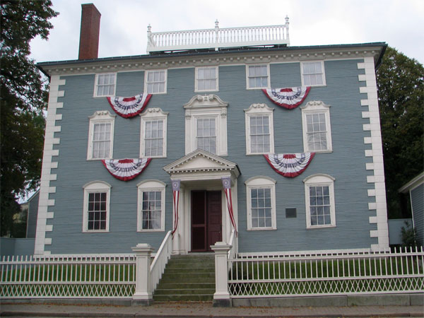
    I started off by visiting the Moffatt Ladd house - a three storey mansion which is a National Historic Landmark. I was given a personal guide of its fascinating interior by one of the colonial dames from the National Society of Colonial dames of America (NSCDA) who own and run the house. It was built in the mid eighteenth century for a wealthy maritime trader and you can see the site of the old port very easily from the house. The top of the house has one of the walkways where people could watch the comings and goings of ships.

    There are a number of other fine houses. Most are only open in the summer months but are typically not open every day. Visiting all of them would occupt at least a full day if not more. Apparently there is a Portsmouth Harbour Trail which takes you past most of them.

    After lunch, I visited the Strawbery Banke Museum. This features an extensive collection of restored Colonial, Georgian, and Federal style architecture, saved from urban renewal by the efforts of historic preservationists. You can see a map of just how big the site is here.

    The museum is dedicated to the study of the lives of people who left their mark on Portsmouth's history and the site is designed in such a way that you can gain an insight into how houses were built, developed and were lived in over the years since the settlement was created.

    Not every house is open every day. Guests learn local history from guides dressed in costume appropriate to the 'age' being represented in each house and who help to make it a living museum. This photo is of the street towards the top of the site and the guide is linked to the Marden-Abbott House and the family-run grocery store which is set out in the era of World War 2.

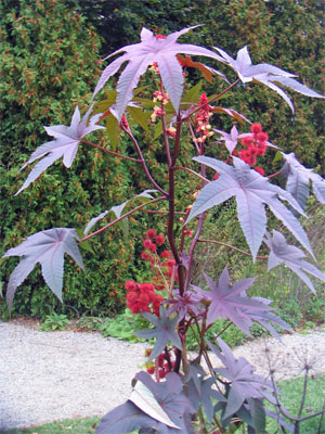
    One of the places I enjoyed the most was the garden of the Goodwin Mansion which had some wonderful planting - both in the garden and also in the 1870 Hot House exhibit. I have however completely forgotten what this plant is called although I keep thinking it's linked to chocolate!

    There are no sketches for this day although I did start a couple. The weather was chilly and kept threatening to rain.

    Links:
    Technorati tags: , ,

    Tuesday, November 07, 2006

    Sunday 24th September: The Interior of the Quaker Tavern B&B

    The Winter Fireplace
    8" x 10", pen and sepia ink and coloured pencil in Moleskine sketchbook
    copyright Katherine Tyrrell


    In Maine I stayed at the Quaker Tavern B&B which is located in West Falmouth – just north of Portland. It's a B&B which has a delightful if slightly quirky host in Donna Little. Donna is a committed environmentalist and certified environmental leader, recycler (she's big on regifting as her shop in the adjacent barn evidences) and historical society stalwart. I think she's done a great job in conserving the house - keeping what could be kept and carefully reinstating what was too far gone to preserve.

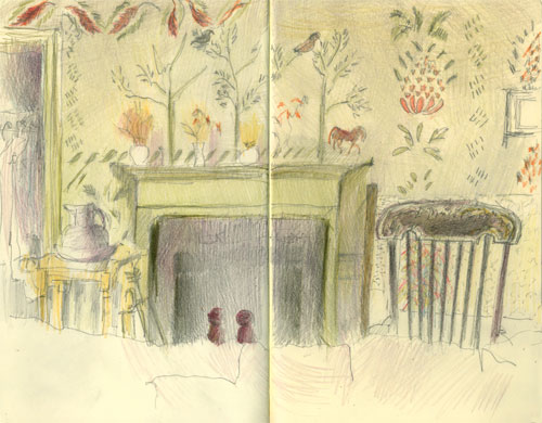
    The building is described as a country federal structure. It was originally built by a family of Quakers (the Halls) and dates back to 1780. Having read the information on the website I asked if I could sleep in the room which has original wet plaster stencil decoration on its walls. It comes complete with genuine traditional cracks in the plasterwork and was simply wonderful! The stencil patterns suggest that it was originally done by Moses Eaton or his son - both well known for their stencil work in New Hampshire and Maine. The pineapple is the symbol for hospitality.

    I did a little bit of research for relevant links about architecture and stencilling in this area. The MB Historic Decor site provides some interesting information about stenciling in new England. Its site states
    These stencils brought color and artistry to rural people eager for their plain walls to be transformed by red and green on backgrounds of salmon and raspberry pink, dove grey, sunny yellow and yellow ochre. Some stenciling appears on natural plaster or whitewashed walls or wood paneling; less expensive backgrounds, but still a way to afford the desired decoration.
    I've found a pdf brochure of a 24 page catalogue of Moses Eaton stencil designs. It starts with an interesting overview of the work of Eaton and Eaton Junior. The stencil in the room I stayed in was very like the one on page 5 - except mine also had rather nice trees and a riderless horse over the mantelpiece.

    "The Moses Eaton Bedroom"
    8" x 10" pencil and coloured pencil in Moleskine sketchbook
    copyright Katherine Tyrrell

    I did two sketches of the interior of the B&B
    • One of the wall across from my bed when I was suffering with my head cold. This one is less finished than I would like but is good for the colours and I have some great photos as well and I dare say some artwork will be emerging from the combination of the two! ;)
    • The second (see top) of the fireplace in the Winter Dining Room where I had Donna's organic environmentally friendly and cooked to order breakfast by candlelight every morning. The fireplace is HUGE and a wonderful warm and well worn colour.
    The B&B's website (see links below) provides details of the accommodation and surrounding land and services offered by the tavern.

    Many thanks to Gordon and Kathy for making me feel completely at home during the time I spent in their home, particularly on that Sunday and for the wonderful Sunday dinner cooked by Gordon. It was also really great to be able to spend time with Kathy and see her delightful artwork 'up close and personal'. I also helped her create her new blog called Labswork4Me - "dangerous tails" - an absolute must for any Lab lover!

    Links:
    Technorati tags: , , , , , , , ,

    Friday, October 27, 2006

    Saturday 23rd September: The Farnsworth, the Wyeths and the rain

    "Red Head Yard Dog - in good company"
    pen and sepia ink and coloured pencil in Moleskine sketchbook
    copyright Katherine Tyrrell

    Well I know what the title says but the only sketches I've got for Saturday are ones of the insides of restaurants! My trip to Rockland, Maine with Gordon and Kathy to visit the Farnsworth Art Museum and the Wyeth Centre involved an awful lot of rain - I had hoped to be able to see something of Penobscot Bay, but the weather was simply awful.

    The way in which is rained would have been unbelievable, if I hadn't experienced exactly the same thing the previous Tuesday afternoon coming back from Vermont! What is it about rain in New England - anybody know the answer? It was a complete deluge of the variety which makes roads like rivers and renders headlights absolutely essential.

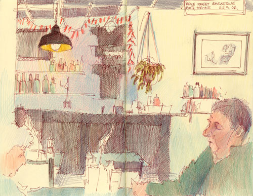
    We stopped for lunch at the Beale Street Barbeque Restaurant in Bath - a little bit of Memphis in Maine! I really enjoyed doing both sketches - especially since it struck me that there was a little bit of a sense of "the ages of man" about them when I looked at them again later! The couple in the Beale Street Barbeque seemed a little incongruous - although having said that they're probably regulars! Very tasty and reasonably priced lunch as well!

    Beale Street Barbeque Lunch
    pen and sepia ink in Moleskine sketchbook
    copyright Katherine Tyrrell

    We found "In Good Company" (see top image) a wine bar /restaurant just a little way down the street from the main entrance to the Farnsworth Museum Shop (details in the travel guide links below). It has a nice atmosphere and good food . Kathy and I enjoyed a bottle of "Red Head Yard Dog" after the visit to the museum - being another one of my dog-loving friends it seemed appropriate!

    OK - now for the art! Although the Wyeths lived in Chadds Ford Pennsylvania, their summer home was in Maine. For those not familiar with the Wyeths, there are some links below. There are three Wyeths of note:
    • NC Wyeth - the grandfather and an artist who produced many illustrations for both books and journals - including Treasure Island and Robin Hood - which are very familiar to many older Americans.
    • Andrew Wyeth - is a representational who has sometimes been referred to as "Painter of the People". He typically works in tempera and watercolour with extensive use of drybrush work and not a lot of use of colour. His palette tends to be on the sombre side. Wyeth has painted a number of iconic images of the people and places in the areas in which he has lived such as "Christina's World" (which is in the Museum of Modern Art in New York. The house in the picture is called the Olsen House is near the Museum and was one in which Wyeth stayed.
    • Jamie Wyeth - is the third generation of this family of popular American painters and is a contemporary realist painter.
    A final note: The Farnsworth is a splendid art museum but I think it probably has some of the most officious security people I have ever come across in visiting art museums in very many countries. I gather I'm not alone in thinking that - enough said.

    Links:
    Technorati tags: , , , , , , , , , , , ,

    Wednesday, October 25, 2006

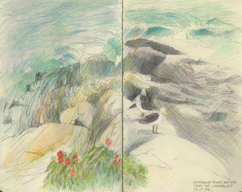
    Friday 22nd September: Pemaquid Point Light - from top to bottom

    Pemaquid Point Light... is the delight of artists, photographers, and tourists. Pemaquid Point itself entrances both land and water visitors by the fascinating northwest-southeast varied veins of rock formation that look for all the world as if great giants had 'pulled taffy' while the rocks were in a molten condition." Malcolm F. Willoughby, The Boothbay Register, 1962

    Bottom Up (Pemaquid Light, Maine)
    8" x 10" pencil and coloured pencil in Moleskine sketchbook
    copyright Katherine Tyrrell

    I woke on the Friday morning with an absolutely stinking head cold - but the day was saved by the owner of the B&B I was staying in (of which more in a subsequent post) producing something which cleared it up immediately! I was amazed and subsequently bought supplies to bring back with me for the next bad head cold!

    So - I started out later than anticipated and then had to get back earlier than the previous day as my friend Kathy was returning from her conference that afternoon. So naturally I decided the best course of action was to go on a very long trip up the coast - the obvious thing to do really!!! Actually it wasn't so silly, as by the time I got to Pemaquid Point the head cold had more or less cleared up and I was feeling a lot more like sketching. That and the fact that it was a day with sunshine and brilliant blue skies and I had appropriate clothing for sitting on the rocks doing sketches.

    The reason I made the long trip was to see the geological formation of igneous and metamorphic rocks at Pemaquid Point - which is rather stunning. Basically about 420-430 million years ago, the muddy sand and silt layers at the bottom of the ocean turned into sedimentary rock. This was subsequently transformed, about 360-415 million years ago, into metamorphic rocks when it experienced extreme heat caused by a geologically active mountain system (under the ocean). Subsequently magma from volcanic activity deep under the earth forced its ways though cracks in these metamorphic rocks. Then at some point the rock was tilted over and forced to the surface where it is now exposed - and eroded by the sea. So what can be seen now are all the edges of the layers of the greyish sediments - which were changed into small crystal rocks - alongside the harder bigger crystal rocks, which are light in colour.

    This is where I sat to draw the lighthouse. I sat on one of the ledges on the rock platform with the waves crashing on to the rocks behind me. I kept one eye on the lighthouse and positioned the other in the back of my head watching the waves!

    When I first started it was very difficult to see what I was sketching because of what appeared to be a boatload of visitors. However they all gradually disappeared and the scene became clear. When that sort of thing happens I just sketch what I can see until I can see better. It's no big deal.

    This is the first stage of the sketch - I'd got the pencil drawing down.

    As I began to add colour it I began to get worried about how close the waves were getting and then noticed that all the visitors had disappeared. Then the spray started to get rather more obvious and so I completed it sitting rather nearer the subject.

    The final version of the sketch of the lighthouse from down on the rock ledge is at the top - and a subsequent drawing was developed which is posted on my main blog here.

    Top Down (Pemaquid Point, Maine)
    8" x 10" pencil and coloured pencil in Moleskine sketchbook
    copyright Katherine Tyrrell
    I then sat at the top just beneath the lighthouse, looking back to where I had been sitting on the rock ledge and sketched the waves crashing on the rocks. This was a lot more difficult than it sounds as the tide was coming in and the sea was boiling with very little that was consistent or rhythmic about those waves. I did however get to add in some seagulls who posed nicely for me on top of the ridge of pegmatite which I was sat upon. The plant in the foreground is a beach rose (rosa rugosa).

    I viewed the exhibition by the Pemaquid Group of Artists at the Pemaquid Art Gallery in the Lighthouse Park - they were celebrating their 78th year!

    I drove home - having forgotten to organise or eat lunch (such is my dedication to sketching!!!) and snacked until I went out for a very pleasant meal with friends Kathy and Gordon that evening. We relived in part some of the events and incidents of our trip out west in July - see Travels with a Sketchbook in the southwestern states of the USA.

    Links:
    Technorati tags: , , , , , , , , , , ,

    Tuesday, October 24, 2006

    Thursday 21st September: "In the footsteps of Winslow Homer - nearly"

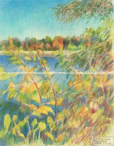
    Massacre Pond, Prout's Neck, Maine (21. 9. 06)
    10" x 8", pencil and coloured pencil in Moleskine sketchbook copyright Katherine Tyrrell

    This was a big sketching day - with three sketches done during the course of the day on top of a fair bit of travelling around. 

    Prior to coming to Maine I had decided that I wanted to try and sketch at Prout's Neck as this was where Winslow Homer used to have a house and where he often drew and painted seascapes. (This is a link to an example). Well that was the idea - easier said than done! I have a rant about the problems I encountered in the next paragraph which I would skip if you're not interested or have heard it all before!

    I really do appreciate how difficult it must be living in places which get swamped by tourists in the summer months - but I don't think I've ever been anywhere in the world that is so restrictive on parking as New England. In the UK we have the National Trust and where you have areas of outstanding natural beauty or historical importance, the land/properties are bought by or bequeathed to the National Trust and it's then possible for everybody to get to see them - not just those who live there. Appropriate arrangements are made so that people can park - but in ways which are not too intrusive. Having timed my holiday so that I would be travelling outside the peak season I wasn't expecting a lot of problems - but I actually had difficulty parking in most places. The worst by far was Prout's Neck (hence this rant) which had a locked barrier across the car park when I arrived and a lot of road saying no parking at anytime. In the end I parked just off the road and hoped that I'd understood the local parking laws correctly! I was then faced with a a causeway and a very high barrier designed to restrict entry to the beach - which looked like it was designed to keep everybody out except those with passes! Except there was nobody around to buy a pass from or to open the car park gate!!!%&*^!!!

    The sketch at the top of the page is of Massacre Pond at Prouts Neck. This is a former salt lagoon which is now a freshwater pond and is located either side of the causeway out to Scarborough Beach. It gets its name due to two separate attacks by local Indians on settlers in the area in 1677 and 1703. 

    Unfortunately for the entire time I was doing this sketch I kept thinking that my nose was being assaulted by a bad smell - but this was the best viewpoint by far - so I decided to suffer for the art and resolved to pack a noseclip next time! In retrospect I think I might have found a favourite point for dog walkers who couldn't get as far as the beach - sat as I was just short of the great big barrier to the beach.

    I loved the colours of this pond and the foliage. It was a brilliant day in terms of a cloudless blue sky and all the colours were looking very strident and as if they were begging for a colourist to come along and get the oils and the easel out! This one is very definitely getting done as a larger work.

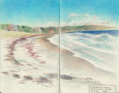
    I finally managed to suss out how to get access to the beach and the next sketch is of Scarborough Beach on the eastern seashore of Prout's Neck - just beyond Massacre Pond and looking towards the area where Winslow Homer has his house. I had one of those "[insert artist's name] walked here and sketched her and painted here" moments. I try to manage at least one of those on each holiday - it always makes you stop and look again at the landscape with a fresh eye! ;)

    What I was amazed about was that there was absolutely no indication anywhere on Prout's Neck that one of the most well known American artists both lived and painted in this area. Such a complete contrast for example to the way the French treat prominent artists who have painted in their country - go to St Remy in Provence and you can follow a walk which leads you to all the spots where Van Gogh painted famous paintings when he stayed in the asylum there.
     
    Scarborough Beach, Prout's Neck, Maine 8" x 10" pencil and coloured pencil in Moleskine sketchbook copyright Katherine Tyrrell

    I got some great photos of the surfers enjoying the surf. Drawing wet sand and surf is never easy and while the colours are pretty much OK the perspective drawing could be better.
     
    Lake Sebago, Maine
    8" x 10" pencil and coloured pencil in Moleskine sketchbook copyright Katherine Tyrrell

    The last sketch if of Lake Sebago - the deepest and second largest lake in the Maine and which is the prime water supply for Portland and surrounding areas. Difficult to know what to do with this as a subject as flat huge expanses of water are not something I often want to do unless they have interesting patterns or colours on them - which this one didn't. But the clouds did!

    In the evening Gordon (of "Gordon drives Dome Valley with the boss" fame) showed me the sights of Portland and we had dinner at a very nice restaurant whose name I forgot to note down! [I'll update when I've got the data refresh done - otherwise known as contacting Kathy!

    Monday, October 23, 2006

    Wednesday 20th September: A friendly warning from the local police!

    Sawyer Crossing / Cresson Bridge, Swanzey 20.9.06 midday
    8" x 10" pencil and coloured pencil in Moleskine sketchbook
    copyright Katherine Tyrrell

    On the Tuesday evening, after drawing art cards of apples on Monday night, Nicole and I then drew pears. An account of the fascinating experience of drawing the same subject next to one another on the same support - with different results - is set out in New Hampshire Pears on my other blog.

    Then on Wednesday morning, after a good look round the delights of Keene with Nicole and Lizzie (and a visit to yet another art shop which unfortunately is closing down its art materials section) I left Keene to drive to the coast of Maine.

    However I decided that before I left New Hampshire that I should try and visit at least one of the covered bridges in the area. There's a whole bunch of them just south of Keene round about the Swanzey area.

    Sawyer Crossing or Cresson Covered Bridge in Swanzey was built in 1859 or so it says on the sign on the entrance to the bridge. According to the New Hampshire Covered Bridges website the 1859 covered bridge in fact replaced the original bridge built in 1771 and is situated near the site of an old Indian community.

    This is what Cresson Bridge looks like from the side. People started to cover bridges to protect truss work and planking from harsh weather in the early nineteenth century. Most bridges were built by local people and consequently had design features local to that area. You can find out more about covered bridges and covered bridge societies in the north east of the USA/New England on the Covered bridge website and the National Society for the Preservation of Bridges.

    Now for the story behind the title for this post! I parked my car in a small car park off to the left of the bridge and then did my usual "walk around / look at a subject from every angle / decide what is the best composition" study prior to starting the sketch. I finally settled on a head on shot which gave me good contrast between the darkness inside the covered area and the light on the far side - plus a few sightlines to help the eye travel through the picture. This was possible because the road bent round just before the bridge and had a stop line (so cars could check whether anything was coming through the bridge before proceeding) and I could sit on the grass at the side of the road next to the stop line. Very few cars passed so I felt very safe.

    Part way through the sketch another car pulled up in the car park, a lot of teenage boys got out, pulled up the hood (I'm really getting into the 'local' language!) and started playing music very loudly - which, as you can imagine, I was just ecstatic about given my nice peaceful spot. When I realised that they were playing some very aggressive rap music - which made nasty comments about women - I started to get quite concerned but stayed sitting where I was. Then a car zoomed through the bridge very fast with one of those "I've got a bigger more powerful engine than you have" noises. So parked car packed up very fast and I then had 5-10 minutes of cars driven by youngsters zooming through the bridge backwards and forwards very fast. Well I was nearly finished and there was no way I was moving - so I continued to sit there.

    Five minutes later - just as I was finishing a police car pulled up. I guess one of the houses in the neighbourhood had alerted them to the silly and noisy antics of the juveniles and they were checking it out. A policeman hung out the window and said "Nice drawing - but it's not very safe sitting where you are" (which I guessed referred to the antics of the boy racers). I think I told him that I kept an eye on cars coming towards me and just stared straight at the face of any driver going too fast!

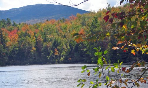
    On the drive across to Maine (Route 101 then I-95), I stopped to take a few photos of trees which were on the turn. These were taken from the side Route 101 across Dublin Pond with Mount Monadnock in the background. The latter is reputedly one of the most climbed mountains in the USA - or the world depending on the perspective of the website author!

    I wish I could remember what was the name of the small store I stopped at to pick up some lunch - it had great sandwiches and some really 'knock your socks off' wasabi peas - which I decided that, along with yoghurt covered cranberries, were my "snack of choice" for munching on long drives in New England. I don't suppose they did anything for my waistline though!

    Links:
  • Sawyer or Cresson Covered Bridge, Swanzey, New Hampshire
  • New Hampshire Covered Bridges
  • Covered Bridges of the Northeast USA
  • National Society for the Preservation of Bridges
  • Mount Monadnock State Park

  • Technorati tags: , , , , , , , , , ,